-
Bus, Airlines
-
3 Stars Hotels
-
5320 metres
-
Bhutan
-
Jul, Aug,Sep & Oct
-
Eco-Tour, Hiking,Treking
-
All meals during the trek
-
English, Spanish, French, Chinese
-
Hard
-
2-15
-
25
-
65
Overview
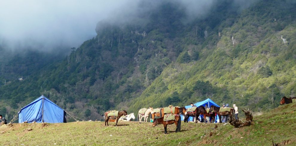
The Snowman Trek is an extension of the beautiful Laya Gasa Trek, and leads from Laya into high altitudes of the Bhutanese Himalayas. It takes tough and enduring trekkers into the Lunana region and further on to Gangkhar Puensum and Bumthang or down to Sephu in Trongsa district, depending on which route you choose. The Snowman trek leads through the most remote areas up to very high altitudes. Trekkers have to camp in altitudes above 5,000m more than once, and depending on the seasonal temperatures, the camps are sometimes on snow.
Highlights
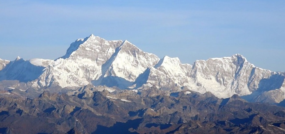
- Snowman Trek: Extension of Laya Gasa trek. Trek duration 24 days, one of the Top ten toughest treks in the world. Starts from Paro and ends at Nikachu. Walking distance 348 kms, average walking distance 16 kms a day and average walk time is 7 hours. Highest point is 5320 meters. The trek route passes through Yak Herders’ camp at 3980 m, grazing ground of Blue Sheeps (National animal of Bhutan), remote village of Laya and Thanza and crossing over many passes namely Nyeli La (4890 m), Jhari La (4747 m), Shingela (5005 m), Jaze La (5050 m), camping near Tsho Chena lake (4800 m) and Thampe Tsho at 4200 m. You can view Mt. Jumolhari (7314 m), Masagang (7165 m), Table Mountain (7100 m), Gangla Karchung (6395 m).
- Discover some of the most sacred Buddhist monasteries and temples in the Himalaya.
- Hike up to the famous Taktsang Monastery, perched on a cliff 900m above the valley floor.
- Traverse beautiful landscapes from lush valleys to dense forests.
- Camp overnight beneath some of Bhutan’s most impressive mountain peaks.
Itinerary
Upon arrival at Paro airport, received by the Representative from Bhutan Druk Adventure and transfer to the hotel.
After lunch, drive to the ruins of Drukgyel dzong, now in ruins was built by Shabdrung Ngawang Namgyal to commemorate the victory over the Tibetan invaders in 1644; the dzong name’s means indeed “The Victorious Druk”. The Dzong was used as an administrative center until 1951 when a fire caused by butter lamp destroyed it. Then visit Kyichu Lhakhang, one of Bhutan’s oldest and most sacred monasteries dating from the introduction of Buddhism in the 8th century. Dinner and overnight in Hotel.
After breakfast, visit the Ta dzong, an ancient watchtower, which has been since 1967, the National Museum of Bhutan followed by visit Rimpung Dzong (Paro Dzong) built in 1646 by Shabdrung Ngawang Namgyal. The Dzong presently houses administrative offices.
Day hike to Taktsang monastery, the famous “Tiger’s Nest”. The hike which is all uphill takes about 2 /3 hours through villages and pine forests. The monastery which clings to a huge granite cliff 800 meters above the Paro valley was devastated by fire in 1998 but the Royal Government has taken immediate steps to restore the monastery to its original structure. It is believed that the Buddhist saint Padmasambhava came in the 7th century on a flying tigress and meditated in a cave for 3 months. The demons were subdued who were trying to stop the spread of Buddhism and converted the Paro valley to Buddhism. During the end of the 17 century, a monastery was built on the spot where the saint meditated and it is a pilgrimage site for every Bhutanese to visit once in their life time.
Dinner and overnight in Hotel.
Distance: 22 km. Hiking time: 7 to 8 hours.
Leaving Sharna the trail continues upriver and the route winds in and out of rhododendron and blue pine forests. When we enter Jigme Dorji National Park keep your eyes open for wildlife and changes in vegetation as we continue to climb in elevation. Tonight we camp in Thangkthanka (3520 m)
Distance: 19 km; Hiking Duration: 5 to 6 hours.
An hour out of camp this morning we leave the tree line and head into the high mountains. At the halfway point of our hike, we cross Tengethang, a winter home of the migratory yak herders. Arriving at Jangothang (4040 m / 13,250 ft), we can watch the sun set on Mt. Jhomolhari (7314 m) and Mt. Jichu Drake (6989 m).
The first of our acclimatization days, we have many day-hiking options. The first is a three to four hour excursion up the ridge to the north for great views of Jichu Drake. The second is to hike up towards the head of the valley in the direction of Jhomolhari. The third is a trek up the main valley towards the last house and onward toward Jichu Drake, this gives a great view of where we will be going in the next few days. The final alternative is a fishing expedition to Tshophu, a high-altitude lake about a two hour hike away.
Distance: 20 km; Hiking Duration: 6 to 7 hours.
Heading uphill from Jangothang we cross the first of many major passes. The Nyile La pass at 4890 m (16,135 ft) is about a four hour ascent. Descending the other side we will encounter sparce juniper and rhododendron and pass many yak herder camps. From this area on we start to see herds of blue sheep. Arriving in Lingshi we set up camp at 4150 m.
Distance: 14 km; Hiking Duration: 4 to 5 hours.
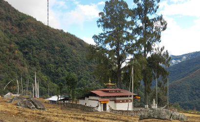
This morning we will visit Lingshi Dzong, also known as Yugyel Dzong in the 17th century, it was used in the past to control travel between Tibet and Bhutan. Since today’s hike will not be as long, the pace will be more relaxed. Upon reaching the camp at Chebisa (3850 m / 12,600 ft), we will have time to visit Chebisa village and see a slice of Bhutanese village life.
Distance: 13 km; Hiking Duration: 4 hours.
Crossing the Gombu La pass at 4350 m (14,300 ft), we descend into a rhododendron filled valley, and continue past some yak herder camps to Shakshepasa where we camp at 3980 m (13,100 ft).
Distance: 18 km; Hiking Duration: 7 to 8 hours.
An early morning start will get us on the way to Jhari La pass at 4747 m (15,600 ft). Decending to Tsharijathang, the valley where herds of Takin (the national animal of Bhutan) are normally seen. From here we climb to our camp at Robluthang at 4160 m.
Distance: 19 km; Hiking Duration: 7 to 8 hours.
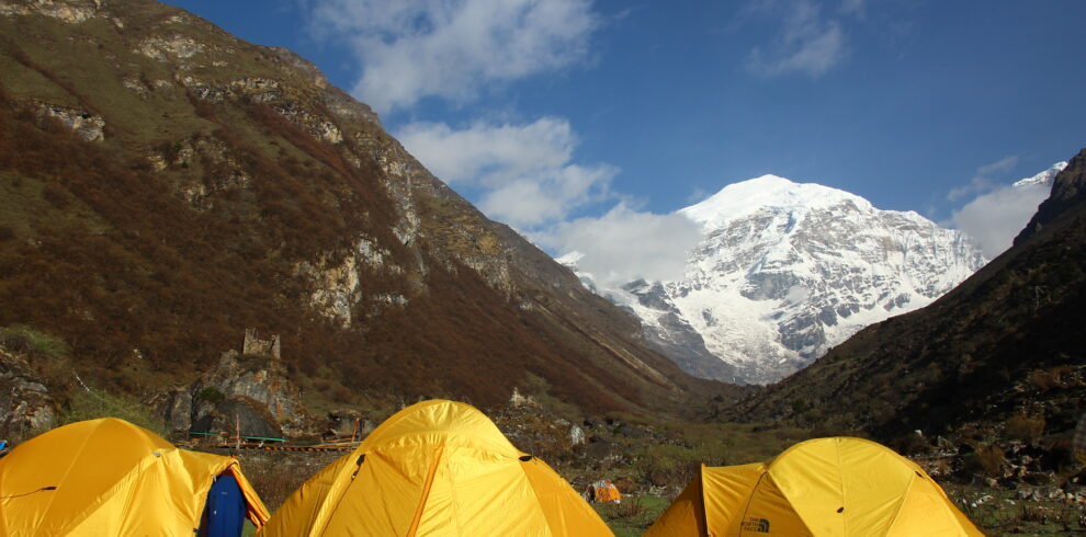
Starting early a strenuous hike leads to the Shinge La pass at 5005 m (16,650 ft). Descending to Lemithang we’ll see Mt. Gangchenta (6840 m) and the glacially carved Gangchhenta valley. Gangchhenta means Great Tiger Mountain. We camp at 4140 m.
Distance: 10 km; Hiking Duration: 4 to 5 hours.
A shorter hike follows a trail in and out of a heavily wooded, uninhabited valley. Climbing up out of the forests we will be rewarded with some great views of Gangchhenta and Masang Gang (7165 m) mountains. We camp at Laya at 3840 m.
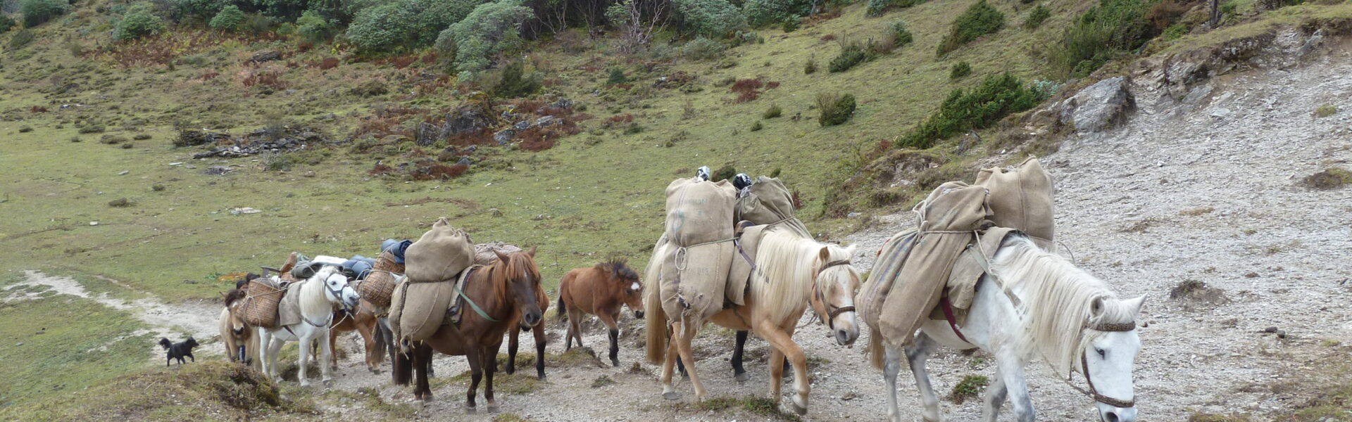
Staying in Laya for the day we will get a chance to see the village with its community school, hospital, archery field and the first shop since the Paro Valley. Laya is a unique village of about 800 people with their own language, customs and distinct dress. The women keep their hair long and wear peculiar conical bamboo hats with a bamboo spike at the top. They wear a lot of silver jewellery on their backs, on many women this display includes an array of teaspoons.
Distance: 19 km; Hiking Duration: 6 to 7 hours.
The trek leads gradually downhill to the Lunana trail junction, then makes a gradual climb to the camp through a forest of conifers, maple and rhododendron. The trail improves and becomes wider as we climb out of the river valley. We camp at Rodufu near a small stream at 4160 m.
Distance: 16 km; Hiking Duration: 8 to 9 hours.
It is a long hike, first crossing the Tsimo La pass at 4950 m (16,200 ft). Descending to Narethang we pass some dwarf rhododendron and hike in the shadow of Gangla Karchung peak (6395 m). We camp at 4900 m.
Distance 18 km; Hiking Duration: 5 to 6 hours.
Climb to Karchung La pass at 5240 m (17,187 ft) and down to the glacial lakes that are the source of the Tang Chhu river. Above the lakes are the mighty peaks of Jejekangphu Gang (7300 m) and Tsenda Kang (7100 m). We camp at Tarina, 4020 m.
Distance: 15 km; Hiking Duration: 5 to 6 hours.
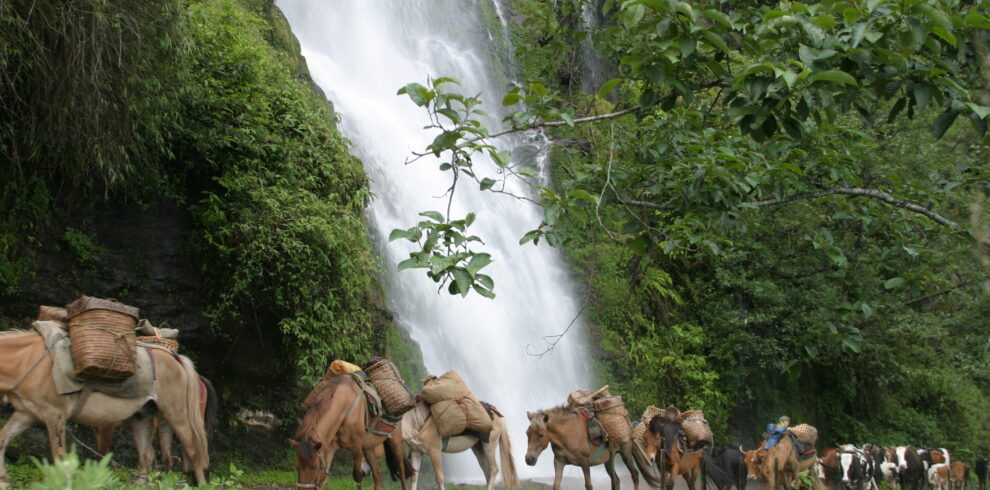
The walk leads down through conifer forests, following the upper reaches of the Pho Chhu river. The trail then climbs over a ridge and drops to the village of Woche at 3940 m. The trek has now entered the Lunana region.
Distance: 19 km; Hiking Duration: 7 to 8 hours.
It’s a gradual climb from Woche to the Keche La pass at 4580 m (15,100 ft), then downhill to Thega village. The hike continues to Lhedi village where we camp at 3600 m.
Distance: 19 km; Hiking Duration: 6 to 7 hours.
The trail climbs gradually following the main source of the Pho Chhu to Chozo village. At the small Chozo Dzong there are some lay monks. Above Chozo the valley opens as we approach Thanza village near the foot of 7100 m Zogophu Gamp, which is also know as Table Mountain. We camp at Thanza, 4080 m.
This day is a fantastic opportunity to interact with the hospitable local villagers, and explore the beautiful surrounding area, our farthest point in the Lunana valley. Alternatively you can relax around camp and rest up for some of the tough days ahead. As Thanza is a transfer point for horses and yaks, it is important to have a day here for our staff to ensure all the necessary yaks are rounded up by the local herders.
Distance: 8 km; Hiking Duration: 4 hours.
Today is a relatively short, although somewhat steep, climb to a campsite called Danji, part way up to the Jaze la pass. It will allow us to have some extra time in the morning and make a later start. The camp is around 4600 m, with spectacular views of snow-capped peaks! It is an important acclimatization spot.
Distance: 12 km; Hiking Duration: 5 hours.
The first part of the day involves a climb up over three false summits to Jaze La pass at 5050 m (16,570ft). From the pass it is a short downhill trek to the campsite at the lake of Tso Chena at 4800 m. Keep your eyes open for blue sheep during the hike.
Distance: 14 km; Hiking Duration: 4 to 5 hours.
The trail has a series of gradual ups and downs between the snow-capped peaks and across the Loju La pass at 4940 m (16,300 ft) before descending to camp at Jichu Dramo at 4880 m.
Distance: 18 km; Hiking Duration: 5 to 6 hours.
We start with a hard climb to Rinchen Zoe La pass at 5290 m (17,350 ft), the highest on the trek. It is then all downhill to Chukarpo, which is just above the tree line at 4950 m (16335 ft).
Distance: 18 km; Hiking Duration: 5 to 6 hours.
It is a long mostly downhill walk along the river, followed by a climb up to the Um So lake at 4230 m (13,950 ft). In this lake Pema Lingpa found a number of religious treasures. Continuing downhill we camp by the lake of Thampe Tso at 4200 m (13,860 ft).
Distance: 14 km; Hiking Duration: 5 hours.
It is a short walk to the base of Thampe La and a steep climb to the pass at 4580 m (15,100 ft). The trek is then all downhill through rhododendron bushes to the yak pasture of Maurothang where we camp at 3550 m.
Distance: 23 km; Hiking Duration: 7 to 8 hours.
A long final day of trekking will descend through the lovely village of Sephu to finish at Nikachu Chazam, the road head. From there we will drive to a comfortable guest house near Trongsa. This beautiful Dzong is the centre of the region of Bhutan called “Bumthang” (central region). The Trongsa Dzong is the most impressive in the kingdom and can be see from a great distance in its strategic position high above the Mangde Chhu river.
Drive from Trongsa to Punakha. (Approximately 3 hours) In the mid-afternoon, there is a spectacular drive back west across the mountains to Punakha. We will probably stop along the way at Chendebji to visit the Chendebji Chorten, patterned after Swayambhunath in Kathmandu and built in the 19th century by Lama Shida from Tibet. We may also stop at the top of the Pele La pass (3400 m). Overnight in hotel.
Morning visit to Punakha Dzong (the second of Bhutan’s dzongs to be built) which for many years served as the seat of government. The dzong was first built in 1637 and is still one of the largest in Bhutan. Drive to Thimphu. After lunch visit the Trashi Chhoe Dzong, built as the symbol of the capital and then explore the shops along Norzin Lam, Thimphu’s main street. Dinner and overnight in Hotel.
After breakfast, visit National Postal Museum, which is worth a visit for you can get your own picture on Bhutanese stamp right then and there. Get a photo clicked then and there or give a photo of your dear ones and you will get personalized stamps in 5 minutes followed by a visit Memorial Chorten, a monument dedicated to the Third King of Bhutan. Late His Majesty, King Jigme Dorji Wangchuck. The inside paintings and statues provide a very rare insight into Buddhist Philosophy. Changangkha Monastery, Takin Preserve centre and Sangay Gang view point, the Largest and tallest statue of Buddha in the world.
After lunch, hike to Cheri monastery.
In the evening, visit to the Tashichho Dzong, seat of the national government and the Central Monastic Body, including the summer residence of the Je Khenpo (Chief Abbot of Bhutan) and finally visit the Handicrafts Emporium followed by shopping for souvenirs in the shops of Thimphu. Dinner and overnight in Hotel.
After breakfast, drive to the airport and farewell.
Cost
The Cost Includes
- Private guided tour
- Visas for Bhutan
- Airport transfers
- Daily 3 meals (B/L/D)
- Accommodation
- A qualified & licensed English-speaking guide
- An experienced driver
- A tour vehicle
- Entry fees & road permits
- Government fee, royalty, taxes & surcharges
- Mineral bottled water
- Full service & assistance before, during and after your Bhutan trip
- Cook and camp hand who will take care of camp chores and provide wholesome meals.
- Services of horsemen who will look after the yaks & ponies that transport luggage and camp gear.
The Cost Excludes
- Flight into Bhutan (can be arranged with us)
- Flight on other airline to catch Drukair Flight
- Meals at 4-5 stars restaurants
- Hotel stay outside of Bhutan
- Expenditure of personal nature
- Travel Insurance (can be arranged with us)
- Tips for the guide and driver
- Alcoholic drink
- Special Offer :
- Do you have a group of 10 or more? You may qualify for a special group rate. Allow us to make sure your group travels happy and confidently.
Frequently Asked Questions (FAQs)
Requires reasonable walking fitness. An excellent level of physical and mental stamina will be required. Expect to travel through mostly uninhabited areas where supplies will be hard or impossible to acquire. Only the most experienced trekkers should take on these climbs.
The main factors that determine the degree of difficulty of a hiking trail are
1) the roughness of the terrain and
2) the steepness and length of the ascents and descents. Other factors are trail length and total elevation gain.
The combined attributes of distance, high altitudes, weather conditions and remoteness make this a very tough trek and it should only be considered if you have experience and a good level of fitness. The Snowman trek is subject to closure because of snow and is almost impossible during winter
This spectacular 30-day adventure in Bhutan begins with the 25-day Snowman trek into one of the country’s most remote valleys. This is probably one of the hardest high altitude treks, but an incredible experience for anyone who takes the challenge.