Menu

LAYA LINGSHI TREK

17 Days
  • BUS, SUV and Airlines
  • 3 Stars Hotels
  • 5,320 metres
  • Bhutan
  • Apr, May, Aug,Sep,Oct and Nov
  • Eco-Tour, Hiking, Trekking,
  • All meals during the trek
  • English, Spanish, French, Chinese
  • Hard
  • 2-15
  • 18
  • 65

Overview

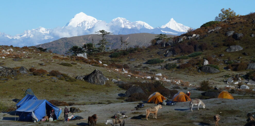
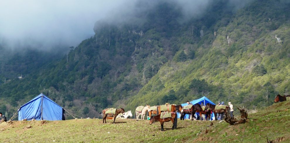
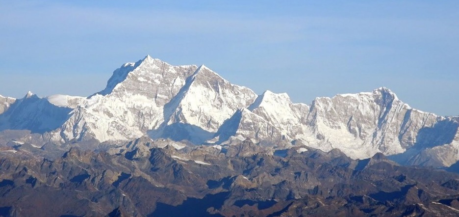
The Laya-Gasa Trek is considered one of the most scenic treks in Bhutan, offering amazing views of some of the most pristine and unspoiled landscapes in Bhutan. This fourteen day, 217 km journey begins at Drukgyel in Paro and takes you through gorgeous alpine meadows, high mountain passes and dense sub-tropical jungles before terminating in Damji in Tashithang.

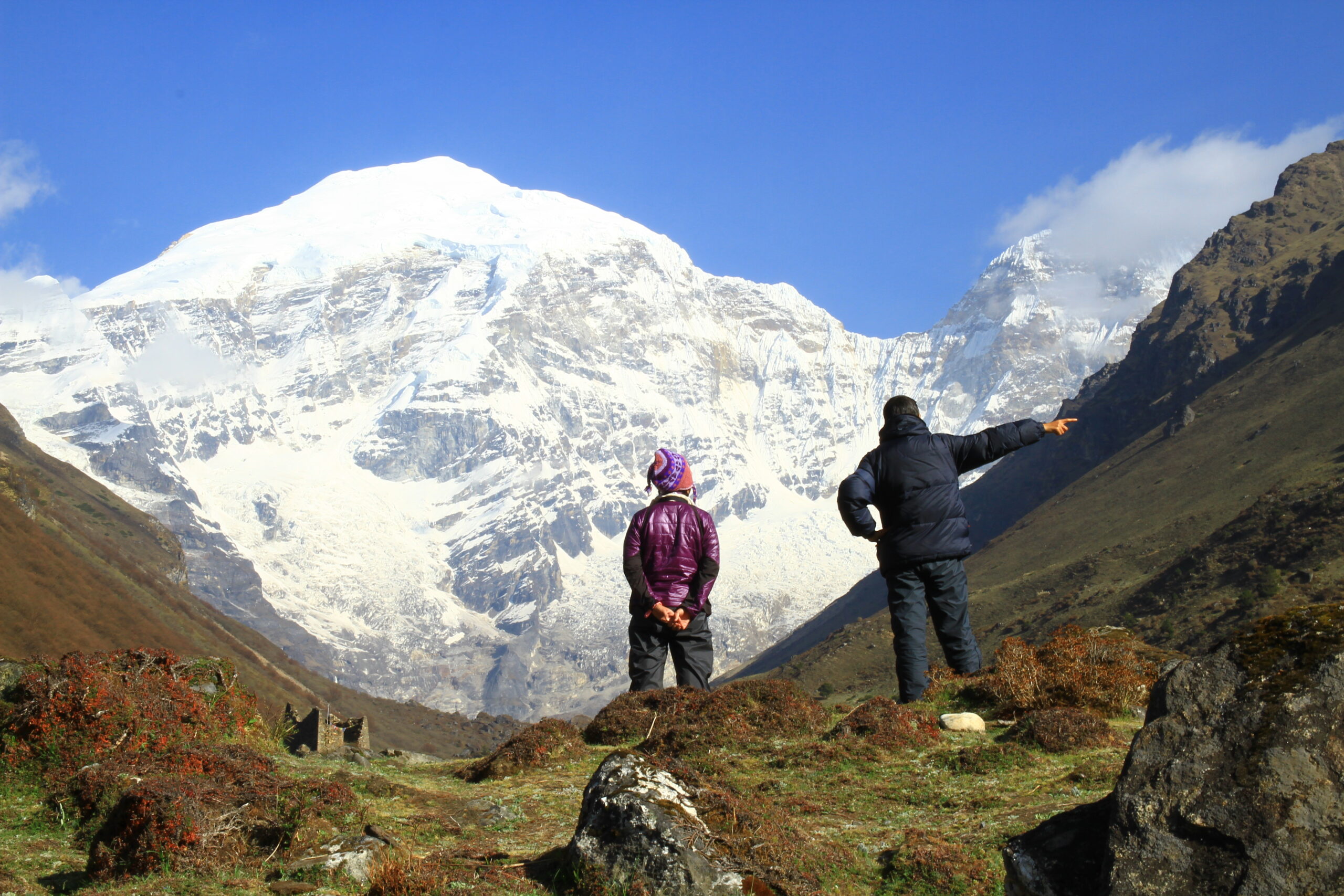
The first five days of this trek follow the same route as the Jomolhari Trek I through Jigme Singye National Park and offer awe-inspiring views of Mt. Jomolhari, Jichu Drake and Tsherimgang. On the sixth day the path diverges and you will depart Lingshi for the camp site at Chebisa, a charming little village adorned with a beautiful waterfall of crystal clear water.

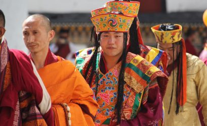
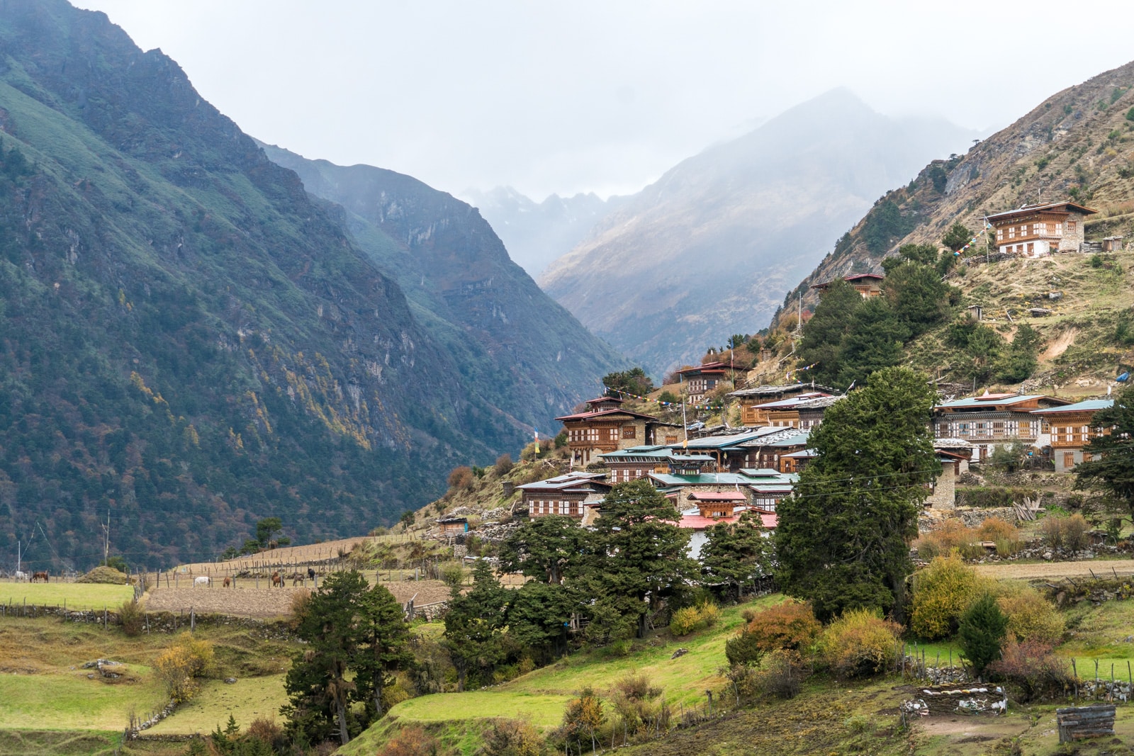
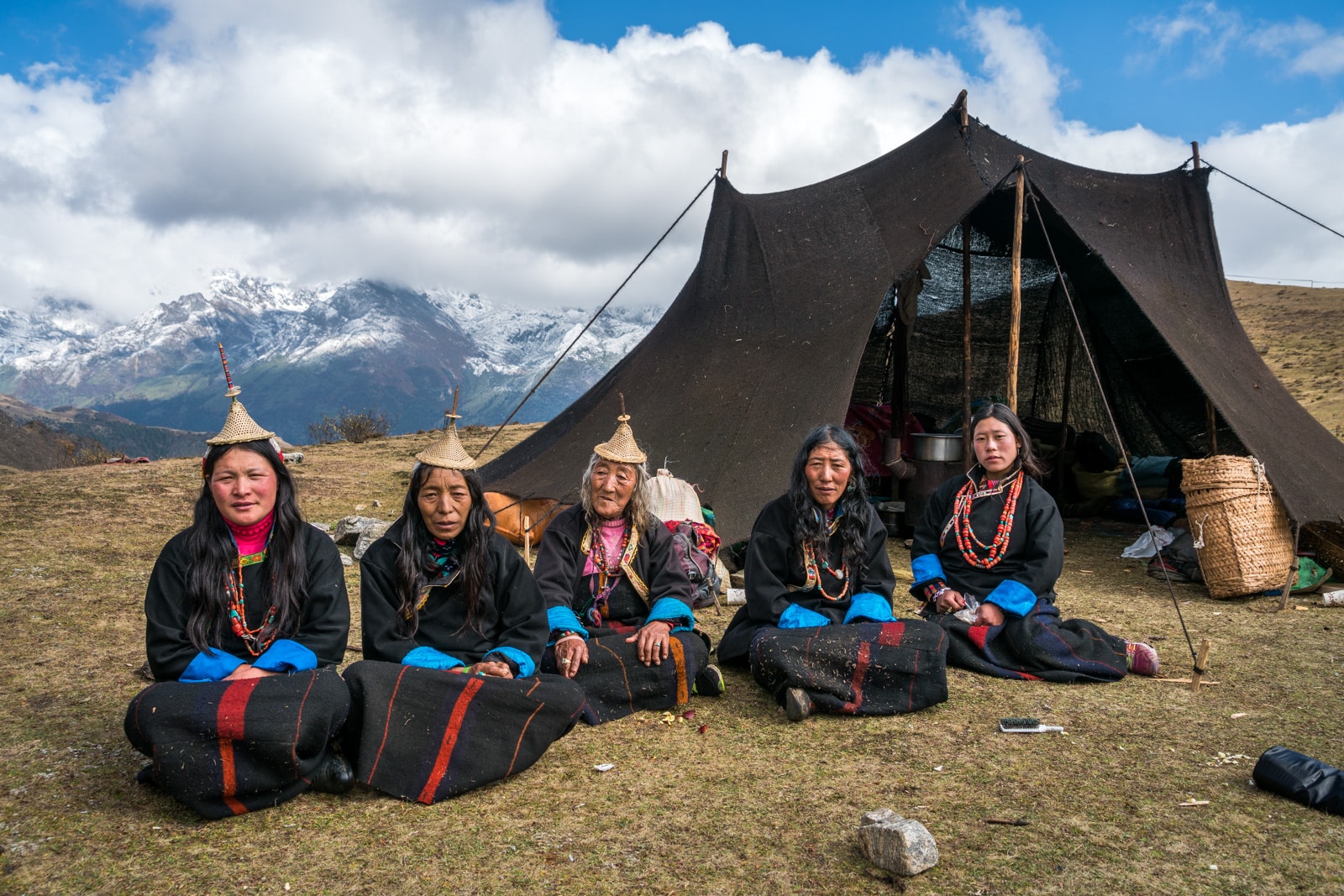
Along the trail you’ll be able to spot indigenous animals such as blue sheep and Takins, the national animal of Bhutan. You’ll travel through remote mountain villages inhabited by Layaps (people of Laya), a distinct segment of the Bhutanese society with unique culture, traditions and appearance. Thhe trek also offers a day of relaxation at the famous Gasa hot springs that is sure to rejuvenate you.

This is one of the more difficult treks offered in Bhutan due to the high altitudes and steep ascents and descents along the path. The best seasons to complete this challenge are in April-June and Mid-September-Mid-November.

Highlights

  • Experience fabulous views of snow-capped mountains such as Mt. Jumolhari and Mt. Jichu Drake.
  • Traverse beautiful landscapes from lush valleys to dense forests.
  • Explore the isolated community of Laya.
  • Soak in the therapeutic waters of the Gasa Hot Springs.
  • Camp overnight beneath some of Bhutan’s most impressive mountain peaks.
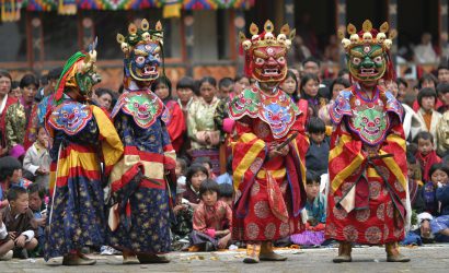
  • Spend time Marvelling at the ancient wall paintings and carvings in Dzongs and temples.
  • Discover some of the most sacred Buddhist monasteries and temples in the Himalaya.
  • Visit many cultural attractions including medieval fortresses (Dzongs), markets and museums.
  • Hike up to the famous Taktsang Monastery, perched on a cliff 900m above the valley floor.

Itinerary

Early morning flight to Paro, Bhutan (Please check the flight timing). The flight from Delhi/Kathmandu is considered as one of the most scenic flight offering the view of the world’s top ten highest peaks. Upon your arrival in Paro airport our guide will be there to welcome you and transfer to your hotel. Later visit the National museum which has all range of collections ranging from pre history of Bhutan. Visit Paro Dzong (Fortress) on foot and continue walking through the oldest wooden bridge still in use. Continue further to stroll around the old Paro town and peep into some local handicrafts stores. Could get some opportunity to see the traditional game, Archery match going on. Evening back to the hotel.
Overnight: Paro | Altitude: 2200m

Morning drive to the base for the hike (3 hrs uphill) to Tiger’s Nest, the most revered temple in the country that literally hangs on a granite cliff over looking the Paro valley. Most of the day will go on the hike. Evening if you have the energy and time visit the Kichu Lakhang, one of the oldest temples in Bhutan which marks the beginning of Buddhism in the country.
Overnight: Paro

Distance: 22Km
Walking time: 9Hr
Sleeping altitude: 3600m
Morning drive to the starting point of the trek. The road ends at the ruins of Drugyel Dzong and a small dirt road starts from there. Before our trek used to start from here but now as the dirt road goes very close to the first day of the camp to we drive all the way up. Follow the Paro Chu upstream through the village of Tshento and a small school. The road ends at the army check post, where your guide will produce your trekking permit. Our trekking crew will be waiting for you and get your bags packed for the trek. Cross the suspension bridge and follow the stream upwards crossing your first camp Shana. The trail is very rocky series of small ups and downs along the Paro Chu and it can be very muddy if it rains. There are few houses on the other side of the river as the trek begins. About 3 hours into the trek, you will come at a junction where a trail branches to go to Tibet, but DON’T go to Tibet. Cross the small bridge and have lunch, after the lunch the trail can get pretty tiring. Finally once you cross the last bridge you will reach your camp site. On a clear day you will be able to see the trip of the Mt. Jumolhair.

Distance: 16Km
Walking time: 6Hr
Sleeping altitude: 4100m
Today you will come across small sparse settlements, and herds of yaks. You will also be crossing the tree line (4000m). Shortly you will be coming across a small army checkpoint and the valley slowly opens up with few settlements just before the camp site. You will get to see one of the remote schools of Bhutan. Our camp at Jangothang will bring us face to face with the majestic Mt. Juomolhari. Jangothang means the land of ruins, you will see ruins of some old settlements, which no one seems to know much about.

Day 5 :
Halt

Acclimatization and rest day. Early morning you will be greeted with majestic Mt. Jumolhari over looking at you. A good optional hike is to climb to the Tshophu Lake at 4300m, which is about 2 hrs hike from the camp. After lunch relax or could got for another hike to see the glacier at the base of Mt. Jumolhari, which will take about another 2 hrs. Both the hikes offer a good opportunity to see herds of blue sheep.

Distance: 17Km
Walking time: 7Hr
Pass to cross: Nyele La, 4900m
Sleeping altitude: 4000m
Heading uphill from Jangothang we cross the first of the many passes. As you start climbing up the view of Mt. Jumolhari and Mt. Jichu Drakey behind you is spectacular. 4 hours of uphill climbing will take you over the very windy Nyele La pass at 4900m. Scree makes it a little tricky to go down the pass on the other side. The descend is steep till we arrive the lunch spot. After 30 mins of walk from lunch point, Lingshi dzong will soon be visible in a distance located at a hilltop. The final descend through thick rhododendrons bushes for 30 mins will lead you to the campsite, which is just before arriving Lingshi village (60 houses). It’s better to camp in the valley by the small stream.

Distance: 12Km
Walking time: 4Hr
Sleeping altitude: 3880m
Morning you will be greeted by Mt. Jichu Drakey and Mt. Tshering gang. Since today’s hike will not be as long, we can afford to wander around a bit. Enroute we can take a short detour to visit the Lingshi dzong, built on a commanding hill by the Shabdrung in the 1600s. About 3 hours into our trek is the dramatic village of Gangyul with 20 houses, surrounded by a natural amphitheatre of cliffs and guarded by Tsheringang mountain. Our camp is in windy Chebisa, a small village with 25 storey stone houses located in a small beautiful valley.

Distance: 16Km
Walking time: 6Hr
Pass to cross: Goku La, 4350m
Sleeping altitude: 3900m
Morning walk around the village and meet the locals. 2 hours of steep climbing from Chebisa will get you over the Goku La pass at 4350m. It’s quite a challenging climb but the view behind you is beautiful and you won’t realize the hardship. From the pass we descend into a rhododendron filled valley, and continue past some yak herder camps to Shakaypasa. Your camp is near a small stream.

Distance: 17Km
Walking time; 6Hr
Pass to cross: Jari La, 4800m
Sleeping altitude: 4000m
The starting of the hike is quite nice and easy with a slow climb and after 3 hours you will be crossing Jari La pass at 4800m. From the pass, its all the way downhill into the picturesque valley of Tsharijatha where herds of takin (the national animal of Bhutan) are normally seen in the summers. The descend from the pass for 2 hours till you reach the bridge is quite challenging with loose sand and stones. From here a small climb will take us to our camp at Tsheringyangu. You might meet some Layaps around this place.

Distance: 18Km
Walking time: 7Km
Pass to cross: Sinche La, 5000m
Sleeping altitude: 3900m
Snow Leopard country. Being highly elusive animals, it is very rare to spot one but their paw marks can be seen occasionally. Starting early, a strenuous hike will get us over the Sinchey La, the highest pass on your trek. 5 hrs of uphill at 5000mts high pass and harsh cold weather could be very challenging. Once you reach the pass, the breathtaking view of the mountain peaks is worth the challenge. Descending to Limithang we’ll see the snow covered peak of Gangchenta (6840m) and the glacially carved Gangchenta valley. Gangchenta means Great Tiger Mountain. As you descend through the rocky trail, after more than an hour you will be seeing a beautiful glacier lake with an abandoned house made out of stone.

Distance: 10Km
Walking time: 5Hr
Sleeping altitude: 3800m
Morning you will be seeing Gangchenta right behind your camp. After breakfast, follow the small stream coming from the Gangchenta glacier lake. Today is one of the easiest hike requiring very little climb. Just need to follow the valley towards south crossing few small streams. Since you are nearing Laya, we will come across Layaps going to tend to their yaks. We will be entering Laya from the west, through narrow cobble stone paths between houses, to camp in the wheat field near the school. Laya is the biggest village you will be crossing with around 120 houses.

Morning could walk around the village and meet the locals. It’s quite a happening village. There is a small school so could pay a visit too. If you are interested to go for longer hikes, could hike (1 hr) to Longola, which offers beautiful view of the mountain peaks including Masagang and a small village at the other side. On the way you will see a small lake where Yaks will be grazing and could spot some Blue Sheep. Back to camp for lunch. Afternoon relax in your camp.

Distance: 16Km
Walking time: 6Hr
Sleeping altitude: 3100m
Start your hike through the village. 2 hours downhill from Laya is Taktsimakhang, a small army check post. Little further from the army camp the trail branches into two, a small trail towards left is to go to Lunana, for the Snowman trek. Do not go left as you are still not ready/fit for the snowman. Follow the river crossing few small bridges with some easy climbs and descend finally descending to Koina valley. The trail is quite bad and confusion due to flash flood few years ago so at time you have to make a small detour. Camp by the small river side. Koina has often been described as the worst camp site in Bhutan, especially when it rains.

Distance: 15Km
Walking time: 5Hr
Junipers and spruce give way to pine tress. The circular Gasa dzong can be seen as you as you climb down the very rocky trail. Due to it’s remoteness Gasa province was the last province to be connected with road. Our trek ends here and our trekking crew will wave us goodbye at Kabina. Drive to Punakha (4 Hrs) through Damji and Kabina village. As the road is new so it’s still not complete and not in good condition but the drive is very beautiful. Upon arrival, relax in the hotel and enjoy the view from your hotel.
Overnight in Punakha| Altitude: 1350m

If you are staying in hotel Meri Puensum, hotel Zandopelri or hotel Densa, early morning it will be a treat to walk up to the hilltop to visit the nunnery and interact with the nuns and enjoy the magnificent view of Punkha and Wangdi valley. Later after breakfast drive to visit Punakha Dzong (fortress), which houses the most elaborated temple in the country. This is a must to see fortress in Bhutan and a fine example of Bhutanese rich Art and Architecture. Later taka a nice hike through the paddy field and old village to visit Chimi Lakhang, the temple of fertility associated with religious art of phallus. After lunch, start your drive for Thimphu crossing over Dochula pass (3200 mts). If the weather permits one can enjoy a spectacular breath taking view of the highest mountain peaks of Bhutan at a sight that stretches almost 180 degrees. Take a break and walk around the newly built 108 stupas and continue your drive for the capital town, Thimphu. After 5 PM, if time permits, visit the fortress of Thimphu, Tashichho Dzong, which houses the throne of the king. Evening walk around the happening town, the largest and the most crowded town in Bhutan.
Overnight: Thimphu| Altitude: 2300m

Morning visit the happening weekend market (Friday, Saturday, Sunday) where the locals from the surrounding villages come to sell their produce. They sell their goods and in return they buy their basic necessities. In olden days, bata system was practiced by everyone. Visit the traditional Hand Made Paper Mill. Visit the School of Arts and Crafts where students learn 13 different arts used predominantly in Bhutan. Visit Folk Heritage Museum which explains how a traditional house used to be like in the olden days. Later visit the National Library which houses the collection of Bhutanese rich religious text and the contemporary Buddhism teachings from master all around the world. Visit the Memorial Chorten (temple) built in memory of the late 3rd King. This place now happens to be a get together point for the elderly people, who spend their whole day chanting prayers and meeting their friends. Drive further up to visit the largest and the newly built statue of Buddha offering magnificent view of entire Thimphu valley. Later drive back to Paro. Hot stone bath available at an additional cost. Farewell dinner with your guide.
Overnight: Paro

Day 17 :
Departure

Morning transfer (15 mins) to the airport for your departure flight. Your guide will bid you farewell at the airport.

Cost

The Cost Includes

  • Private guided tour
  • Visas for Bhutan
  • Airport transfers
  • Daily 3 meals (B/L/D)
  • Accommodation
  • A qualified & licensed English-speaking guide
  • An experienced driver
  • A tour vehicle
  • Entry fees & road permits
  • Government fee, royalty, taxes & surcharges
  • Mineral bottled water
  • Cook and camp hand who will take care of camp chores and provide wholesome meals.
  • Services of horsemen who will look after the yaks & ponies that transport luggage and camp gear.Full service & assistance before, during and after your Bhutan trip

The Cost Excludes

  • Flight into Bhutan (can be arranged with us)
  • Flight on other airline to catch Drukair Flight
  • Meals at 4-5 stars restaurants
  • Hotel stay outside of Bhutan
  • Expenditure of personal nature
  • Travel Insurance (can be arranged with us)
  • Tips for the guide and driver
  • Alcoholic drink

FAQs

How fit do I need to be to do this trek?

The Laya Lingshi Trek is considered to be the second most difficult trek in Bhutan, with the Lunana Snowman Trek being the toughest.

Requires good walking fitness. Moderate treks will reach slightly higher altitudes with more difficult days included. Expect longer days of walking and stronger inclines throughout the trek. Climbers should be healthy, reasonably fit and exercising regularly.

How long do we walk every day when doing Laya Lingshi Trek?

On average, you walk about 4 to 6 hours per day. One or two days can be as less as 4hrs and one or two days can be as long as 7hrs.

What is the highest altitude reached in this trek?

The highest altitude reached is 5320m .

Map

You can send your enquiry via the form below.

LAYA LINGSHI TREK
2% Off
From $5,700 $5,600
/ Adult
From $2,100 $0
/ Child
  • Best Price Guaranteed
  • No Booking Fees
  • Professional Local Guide
  • BUS, SUV and Airlines
  • 3 Stars Hotels
  • 5,320 metres
  • Bhutan
  • Apr, May, Aug,Sep,Oct and Nov
  • Eco-Tour, Hiking, Trekking,
  • All meals during the trek
  • English, Spanish, French, Chinese
  • Hard
  • 2-15
  • 18
  • 65